Tech-savvy sophomore only student on interdisciplinary water study team in Africa
February 15, 2016
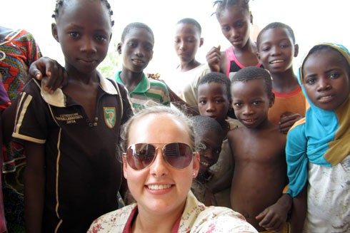
Paige Williams of Radford, Virginia, headed to her interview at the Center for Geospatial Information Technology last May hoping to land a part-time job. The next day she had a plane ticket to Burkina Faso. The rising sophomore majoring in environmental informatics had just earned a spot on a team conducting field research on multiple-use water services in the West African country.
Project leader Ralph Hall, assistant professor of urban affairs and planning, enlisted specialists from several programs at Virginia Tech for the project, combining expertise in water and sanitation systems, public health, gender issues, statistics, data visualization, and geospatial representation. “Paige was the only student; the rest of the team were faculty,” he said. “That can be very intimidating, but she did really well.”
Hall tapped Peter Sforza, director of the Center for Geospatial Information Technology, to help develop a data management and visualization platform to support water services planning. Since Sforza couldn’t travel with the team, Hall asked him to find a substitute. “We needed somebody with GIS skills — hands-on, using the software and understanding the data sets,” Sforza explained. “I knew this was the type of student the environmental informatics program would have.”
Williams went to the interview expecting to help with small projects at the center. But when Sforza mentioned the opportunity to conduct fieldwork in Burkina Faso, she immediately volunteered. In the month before the team left for Africa, Hall and Sforza trained Williams for the task ahead. “On the plane, I was very nervous, like, ‘what did I say yes to?’” Williams admitted. “But as soon as I got there, I thought, ‘I was meant to be here.’”
The goal of the team, which spent 10 days in Burkina Faso, was to combine community knowledge about water sources with biophysical maps to explore ways to advance the multiple-use water services planning process. The research is the first step in the development of a decision support platform that they hope will someday enable decision-makers to leverage all available data to create water services that are sustainable and support rural livelihoods.
To learn more about the social dynamics surrounding water use, the team planned to run two 10-person focus groups in the community of Batondo. But when they arrived, they found more than 100 adults and some 40 children waiting. “It seemed like the whole village was there,” Williams said. “They were so excited to talk to us.”
Williams logged GPS readings at water sources and mapped the results so her colleagues could immediately begin analyzing and sharing the data. “She was clearly able to pull her weight, which is impressive since she was working alongside faculty while experiencing rural Africa for the first time,” Hall said. He hopes Williams can help forge a long-term research initiative. “She’s now our go-to person for processing data and getting information together.”
Williams’ travels have brought a new dimension to her work at Virginia Tech. “She’s gained a perspective on the world now, and we certainly see an impact in her work,” Sforza said. “Now she’s connecting real people and places. Understanding the cultural context of what we’re doing is really important.” Hall also remarked that in the time he has known Paige, “she has transformed from a shy undergraduate student to a confident researcher and valued team member.”