College partners with Blacksburg Children's Museum to showcase geospatial technology, weather
August 15, 2016
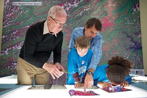
Visitors to the Blacksburg Children’s Museum now have a view of where they are in space and time thanks to an interactive geospatial exhibit with a wall-sized satellite image of the region and historical images of past decades. The new exhibit also includes a weather station displaying current and past weather conditions. “This is our first exhibit that directly addresses our region with geography and weather,” said Museum Director Julene Rice. “It’s amazing.”
Professors Jim Campbell and John McGee, and doctoral student Tammy Parece created the exhibit with support from VirginiaView, an outreach program. “We have been taking geospatial technology exhibits to events and schools for years,” Campbell said. “We have a display with imagery, maps, and computers that offers interactive local scenes.”
McGee added, “We used images from Landsat, which is a series of U.S. scientific satellites that have been imaging the Earth’s surface for 40 years. The exhibit also builds on the online digital atlas of Virginia, which we developed to support Virginia’s educational community.”
When museum volunteer and board member Treesha Baird saw the exhibit at the 2014 Science Festival and the way it engaged children and their parents, she asked if the team could create a permanent display for the museum. “I realized there was a unique opportunity to involve the university with the community, to offer a resource not only for museum members but for teachers,” she said.
VirginiaView funded the 15- by 10-foot mural of a Landsat satellite image of Southwest Virginia and the 10-foot square carpet that shows most of the state. Katie Britt, a doctoral student in geospatial environmental analysis, designed the mural using remote sensing processing and image enhancement techniques.
New light tables provided by the Virginia Association for Mapping and Land Information Systems allow children to examine and mark smaller paper images of the region. Teachers can borrow the tables and images to use with lesson plans being developed by the VirginiaView team and the Virginia Geographic Alliance, from which Assistant Professor Robert Oliver secured funding for the lesson plans and teacher training.
The weather station was supported by a donation from Draper Aden Associates. Lucas Looney, a senior geography major, guided museum visitors as they learned about the images and weather technology as part of a service-learning project. “Weather grabs kids’ attention like you wouldn’t believe,” Parece said. “And it is a way to interest kids in science.”
“The goal is for kids to understand map imagery and relate it to their lives,” Campbell explained. “This develops into understanding concepts of scale, how people use the landscape, and an understanding of their region.”